Saturday May 8th 2021, 23 incredible MCLG Members undertook the collection of water samples which would be screened for DNA fragments of Platypus and Short-finned Eel.
Waterways tested included the East, West and confluence of the Moorabool River, Paddock Creek, Werribee River.
This project aimed to address the lack of data by using eDNA to investigate the current distribution of platypuses throughout the Moorabool Catchment while engaging the local community and raising awareness in conservation issues.
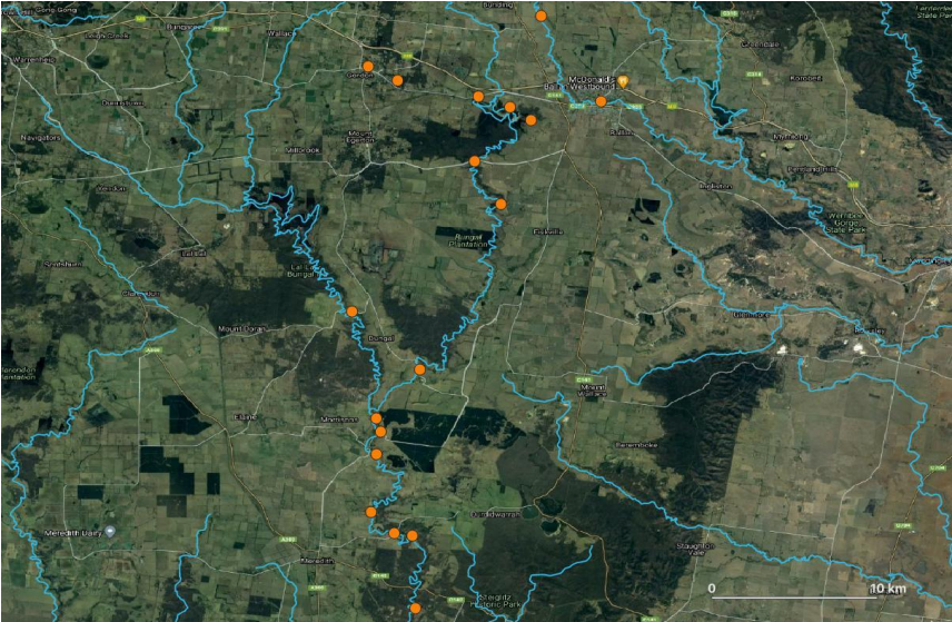
Map showing locations of eDNA samples. Each orange dot represents a sample site.
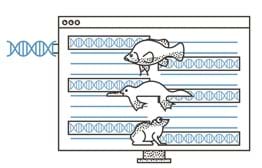
What is eDNA?
eDNA stands for ‘environmental DNA’. It is a non-invasive sampling technique that detects genetic material from a target species secreted into its surrounding environment ( in this case water).
This includes skin, faeces, urine, pretty much any bodily secretion you can imagine Platypus and Eel making into the River – and this is what we are looking for. This genetic material is then screened and tested in the lab to determine the species that it came from.
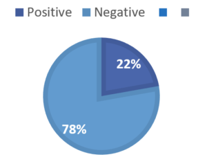
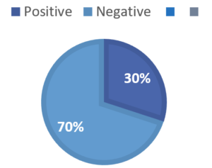
Short-finned Eel Results
Four out of Eighteen samples sites returned positive results, while trace amounts were detected at another four sites.
Positive detections occurred in the upper reaches of both the East and West Moorabool Branches.
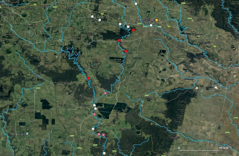
Results from eDNA sampling. Red indicating positive, pink partial and grey no-detection.
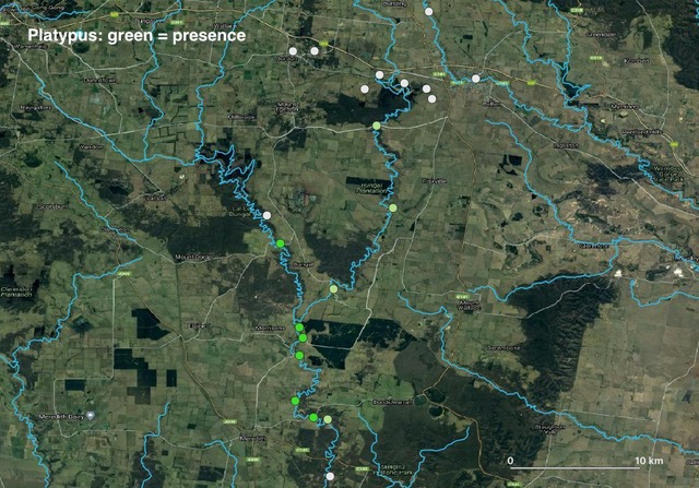
Platypus Results
Six out of Eighteen sample sites returned positive results, while trace amounts were detected at four other sites.
Positive detections occurred in the Moorabool West Branch and downstream of the Moorabool River confluence. Partial detections in the East Moorabool means Platypus may be present but in low abundance.
These partial detections may also be a result of sample contamination or dispersal of DNA from further upstream. Repeat sampling is recommended to confirm presence or absence at these sites.
Results from eDNA sampling. Green indicating positive, pale green partial and grey no-detection.
What does this mean?
With very little historical data we are unable to infer a population trajectory in the Moorabool region. But we now have important baseline data from which we can continue to monitor and track local populations.
Results also show that the middle reaches of the Moorabool River is the stronghold for Platypus in the region. This is not entirely surprising as the vegetation quality in these areas is relatively healthy and receives environmental flows released from lal lal reservoir down the West Moorabool.
Partial and negative detections in the upper reaches of the East Moorabool and Paddock Creek likely reflects the poor habitat quality in these areas.
What can we do with this information?
The Moorabool Catchment has been significantly modified due to widespread land clearing for agriculture, poor water quality, and reduced river flows due to water extraction and diversion. The Moorabool River is estimated to receive only 10% of its natural flow and was rated as Moderate to Very Poor by the last Index of Stream Condition assessment in 2010.
With baseline data established we can continue ongoing monitoring of local populations to track the decline or increase in the abundance of these species. Revegetation projects can be more targeted in riparian areas that have been shown to have poor vegetation quality, improving these areas will improve the health of Platypus populations in the region. Protection can also be given to the areas we now know to have healthy populations.
Collaboration with other Landcare Groups, landholders and Water Authorities can lead to greater conservation outcomes for our local Platypus and Eel populations. Ensuring adequate baseflows throughout the Moorabool system is also vital for the health of our local populations and the overall health of our River Systems.